Hadrian's Wall 2011
Saturday, May 28th 2011
Day 5: Grindon to Steel Rigg (6 miles)
After another satisfying continental breakfast we finished packing up and squared up with Les before leaving a bit later than usual. We were meeting up with Susan’s friend Alison at Housesteads fort, she wasn’t due until 1:30 and Housesteads was only about 2 miles away.
We backtracked along the Military Road to where we had left the path. We could have opted to take the path across the road that would lead us right up onto Sewingshield Crags, but we would have missed out on two turrets and a milecastle, so of course there were no shortcuts.
There’s not much to see of Grindon Milecastle, hidden as it is in an enclosed area of trees. Grindon turret, just a bit further on, had the now familiar interpretation board that seems to be a standard issue for turrets, all containing the same information.
Turret (Grindon I think)
The weather forecast had called for another grey day, with showers. As we started the climb up Sewingshield Crags the wind was gusting directly in our face and then the rain started. Thankfully it didn’t rain for long, but it was the start of a pattern for the day of rain on, rain off. As it was so windy, the waterproofs just stayed on as when they weren’t needed to keep us dry, they kept us somewhat protected from the wind. The wind was so strong at times I thought we were going to be lifted off our feet and over the side of the crags!
Sewingshield Crags are the first of the crags you meet walking E-W that form part of the Whin Sill, a high, rocky outcrop that stretches across Northumberland. Hadrian’s Wall was built along the top of these crags to take advantage of the natural defensive position they offered. To the north there is no further need of the defensive ditch as the sheer drop from the crags provides an effective northern boundary, and the Vallum swings quite a distance to the south, to the flatter land below the crags.
Just past Sewingshields Farm, the path passes through some woods and behind a barn. My walking trip could have been cut short here as I stepped on a flat rock that was partially covering a drain, the rock tipped and I went in up to my knee in the drain! Luckily I was unhurt except for a few bruises and scratches and the other girls helped me out. We replaced the stone so it was solid if stepped on and completely covering the drain before continuing.
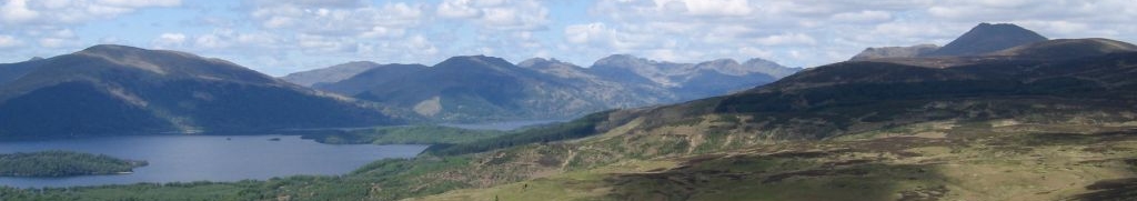
There is a nice stretch of Wall remains as you climb Sewingshields, and even in the bad weather the view from the top is spectacular. We could clearly see the imposing line of hills we would be following for the next couple of days.

Remains of the Wall on Sewingshields Crags

Views of the ups and downs yet to come
We descended, picking our way along the rocky, often eroded path. Due to the recent rain, it was often also slippery and required a good amount of care. This way pretty much to be the case for the next couple of days as we upped and downed along the crags.

Me, enjoying the wind and the crags
We passed Busy Gap (loved the name) and climbed up Kennel Crags before arriving at a wooded area, with a good section of wall greeting us when we emerged. It took us a bit to figure out where the path went, as it looks like it continues on top of the Wall, but in fact, the path drops down to the left of the Wall and there are steps built into the side but it is not well signposted from the east.
At the gate, we left the path to continue uphill towards the entrance to Housesteads Roman Fort. There was another burst of rain and wind and we huddled with some sheep against the Fort’s walls for a few minutes before braving a dash across to the tiny museum. We quickly stamped our passports trying not to get them soggy.
The museum was a warm and dry place of shelter from the torrential rain that was buffeted about by the gusting wind. We paid our site admission, and took a quick look around, but compared to other fort sites, the museum is not the selling point of Housesteads. The most interesting item in the museum is the stone carving of the mysterious hooded Genii Cucullati, a common group of three figures represented in the sculpture of the Romano-Celtic religion. Really what you go to Housesteads for is the fantastic location, high on the ridge, where the Romans truly must have been masters of their surroundings.

View from Housesteads looking back to Sewingshield Crags
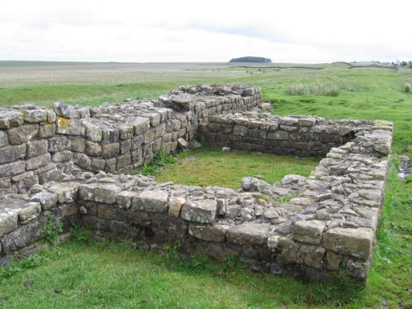
There are also substantial remains, certainly the most of any of the forts built on the Wall. If you aren’t going to go off-piste to visit Vindolanda and are only going to stop at one Wall fort, I recommend this one.

Remains of the fort at Housesteads
Well, the rain wasn’t stopping so we decided to give the fort a go. After a few minutes, Jess decided she’d prefer the National Trust tea room at the bottom of the hill and I agreed, having had a look at the site the previous time I was here. Jacquie and Susan decided to brave the weather so Jacquie could sketch and would join us later, in time to meet up with Alison. The tea room was great, supplying us with warming tea and sandwiches. It had an ample gift shop attached, which was plenty to keep us occupied as the sky slowly cleared.
The AD122 bus delivered Alison right on time and after making sure everyone was fed and watered, we walked back up the hill to explore the site together. Housesteads has some variations from the usual fort layout since it was built on the side of a hill and the remains of pillars are testament to how grand the architecture was even at this remote outpost. Even the not-so-grand remains of the latrines paint a vivid picture of what life was like on the Wall.
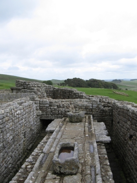
Roman latrines at Housesteads fort
We rejoined the path by walking up the hill from the museum along the western wall of the fort. At this point there is the only section of remaining Wall which you are allowed to walk on top of. Despite an alternative path alongside, it was a temptation we couldn’t refuse.
Emerging from the woods, the Wall continues and we encountered the remains of Milecastle 37. I’ve nicknamed this milecastle ‘the door to nowhere’. It is the only milecastle to still have remains of the north gate’s archway, but the question is, why bother with a gate to the north? About two feet beyond the opening is a sheer drop. No one is really going to come knocking...

‘The door to nowhere’ at milecastle 37
The remains of the Wall from Housesteads going west for most of the rest of our day is known as Clayton Wall, recognisable by the turf on top. These sections of Wall were rebuilt by John Clayton, a great advocate of protection for Hadrian’s Wall in the 1800s.
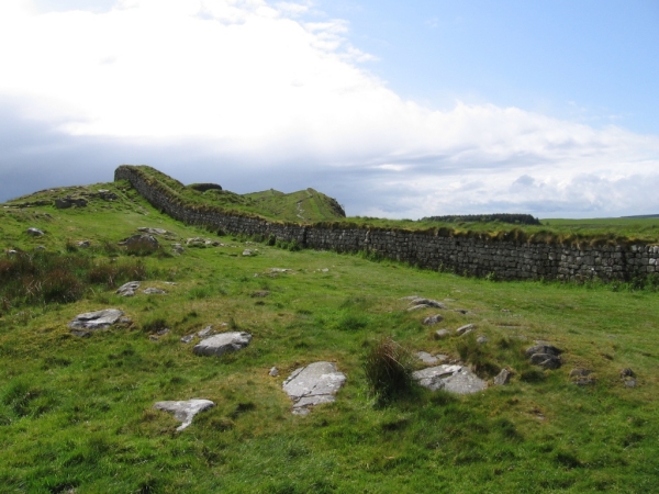
Clayton Wall west of Housesteads
The weather now resembled day one, with soakings now and then interspersed with bright sunshine. In both sunshine and rain, we had great views over Crag Lough from Hotbank Crags.

Looking back towards Housesteads and Sewingshield Crags in
the sunshine

Walking across Hotbank Crags towards Crag Lough in the
driving drizzle
Walking along the edge of Highshield Crags above Crag Lough was fantastic and so was the descent to Sycamore Gap. Sycamore Gap is a great place to stop for a few moments, though it is popular. It’s a well-known film location (Robin Hood Prince of Thieves) and a bit of a poster child for Hadrian’s Wall County, but with good reason. It really is a pretty spot.

Climbing down to Sycamore Gap with a great stretch of Wall
and the Peel Crags ahead

Alison, Susan, Jacquie and Jess at Sycamore Gap
Up a hill and down the hill and we passed milecastle 39, aka Castle Nick, which really shows the typical plan layout of the milecastles that is often described as a ‘playing card’.

milecastle 39, sitting in a dip between two hills
At this point it was starting to rain again so we hurried on and got absolutely drenched as we crossed the Peel Crags. My trousers were so wet they were sticking to my legs! Luckily the rain stopped quickly as I would not have wanted to try and negotiate the cat stairs – narrow, awkward stone steps that bring you down off of the Peel Crags to Steel Rigg – in the driving rain.

looking back at the Peel Crags from Steel Rigg
We left the path at Steel Rigg car park to head to our accommodation for the night, Saughy Rigg Farm. Saughy Rigg is about half a mile north of the Wall, but it is a peaceful walk along a minor road, and I’m sure that if we had called, they would have come and picked us up from the car park. Being the Saturday night of a long weekend, the place was packed, mostly with other outdoor enthusiasts. We had booked a twin and a triple room, and were shown upstairs in the main building to two rooms with massive double beds (one was a four poster) with folding beds set up to make up the desired three and two beds! Score! The old wooden beams and fancy wallpaper really lent the place some extra class and if we ignored our aching feet you almost felt you were in a beautiful country inn on a relaxing holiday, not walking across the country. After getting settled we were invited to have tea or stronger drinks in the lounge with some biscuits and look over the dinner menu. We put in our orders and set a time for dinner before heading back up to our rooms to freshen up. Dinner was brilliant, with all the dishes getting the thumbs up and some of us even managing dessert. Then it was off to bed to the sound of more rain hitting the windowpanes.